Thursday, March 09, 2006
Volcano
Some of the pics I took at Volcano don't look like much. The landscape was really barren in place, so I'll try to be selective so it makes sense to people who weren't there...
Kilauea Caldera

This is the view across the caldera of Kilauea. It's an 11 mile drive around the caldera - so the picture doesn't really show the breadth of it, but it was pretty cool.
Halema'uma'u

This is the crater of Halema'uma'u. This crater used to be much deeper, but the floor has been rising for the last, what, couple of decades or so I guess. The lava is pretty close to the surface underneath - and sulphurour gasses are continually being released - so I couldn't stick around too long. For the first hundred years of it's life it was a lake of boiling lava. It last erupted in 1982, spewing out 1.3m cubic yards of lava. It is the home of the goddess Pele, and throughout the year people perform hulas are performed in her honour and people leave offerings such as flowers and alcohol to her.
South West Rift Zone
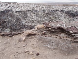
This is the southwest rift zone - a crack in the earth that runs from the caldera summit down to the coast and then under the ocean floor.
Thurston Lava Tube

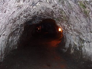

This is a lava tube which if I'd been walking through about 500 years ago, I would have been boiled alive due to the lava that would have been coursing through it. [The tunnel is lit, that's not lava in the discance... just in case...]
Chain of Craters Road
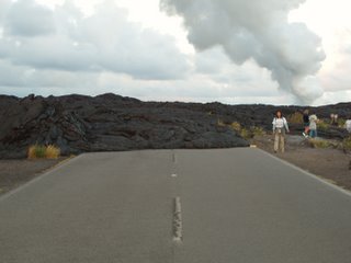
Chain of Craters Road goes all the way from the Caldera down to sea level. It used to go quite a way along at sea level, but since the volcano has been erupting, it has flown down the mountainside to the sea and has cut the road off. This is the point at which lava crosses the road at what has become the end of Chain of Craters Road. It's a good foot high at this point - and is quite dramatic - you'd expect it to keep flowing and self-level but it doesn't.
The steam plume at night


I'm not sure if you can see anything in these two. The print outs I have show quite clearly but I'm not sure if they're coming out on here. This first photo is slightly out of focus, taken from the lava field past the end of Chain of Craters Road - it's about a half a mile walk over the lava just before sunset to the viewing poitn. You can just about make out the orange tinge to the steam plume. This is where the lava hits the ocean. It flows out of a vent called Pu'u O'o further up the mountain, through lava tubes underground (just like the one above) and makes its way to the ocean at which point gases are released and you see the plume of steam. You can only see the orange tinge at sunset and after dark because the cloud comes in and the lava lights up the steam plume then. The second photo is taken after sunset and I think shows the colours better.
Pu'u Loa Petroglyphs


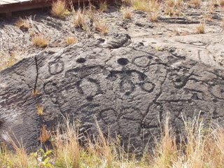
The ancient Hawaiians carved petroglyphs into the hardened lava - the dimples served as receptacles for the umbilical stumps of babies. They hoped that carving these, then placing the umbilical stumps inside the dimples and covering them with stones, the gods would allow their children to live long lives.
Kilaeua mountainside

You can see by the different shading the various laval flows that have gone down the mountain over the years, the most recent being the darkest.
That's it for the volcano. I'll post the rest separately by location.
Kilauea Caldera

This is the view across the caldera of Kilauea. It's an 11 mile drive around the caldera - so the picture doesn't really show the breadth of it, but it was pretty cool.
Halema'uma'u

This is the crater of Halema'uma'u. This crater used to be much deeper, but the floor has been rising for the last, what, couple of decades or so I guess. The lava is pretty close to the surface underneath - and sulphurour gasses are continually being released - so I couldn't stick around too long. For the first hundred years of it's life it was a lake of boiling lava. It last erupted in 1982, spewing out 1.3m cubic yards of lava. It is the home of the goddess Pele, and throughout the year people perform hulas are performed in her honour and people leave offerings such as flowers and alcohol to her.
South West Rift Zone

This is the southwest rift zone - a crack in the earth that runs from the caldera summit down to the coast and then under the ocean floor.
Thurston Lava Tube


This is a lava tube which if I'd been walking through about 500 years ago, I would have been boiled alive due to the lava that would have been coursing through it. [The tunnel is lit, that's not lava in the discance... just in case...]
Chain of Craters Road

Chain of Craters Road goes all the way from the Caldera down to sea level. It used to go quite a way along at sea level, but since the volcano has been erupting, it has flown down the mountainside to the sea and has cut the road off. This is the point at which lava crosses the road at what has become the end of Chain of Craters Road. It's a good foot high at this point - and is quite dramatic - you'd expect it to keep flowing and self-level but it doesn't.
The steam plume at night


I'm not sure if you can see anything in these two. The print outs I have show quite clearly but I'm not sure if they're coming out on here. This first photo is slightly out of focus, taken from the lava field past the end of Chain of Craters Road - it's about a half a mile walk over the lava just before sunset to the viewing poitn. You can just about make out the orange tinge to the steam plume. This is where the lava hits the ocean. It flows out of a vent called Pu'u O'o further up the mountain, through lava tubes underground (just like the one above) and makes its way to the ocean at which point gases are released and you see the plume of steam. You can only see the orange tinge at sunset and after dark because the cloud comes in and the lava lights up the steam plume then. The second photo is taken after sunset and I think shows the colours better.
Pu'u Loa Petroglyphs


The ancient Hawaiians carved petroglyphs into the hardened lava - the dimples served as receptacles for the umbilical stumps of babies. They hoped that carving these, then placing the umbilical stumps inside the dimples and covering them with stones, the gods would allow their children to live long lives.
Kilaeua mountainside

You can see by the different shading the various laval flows that have gone down the mountain over the years, the most recent being the darkest.
That's it for the volcano. I'll post the rest separately by location.
# posted by Sue Lambert @ 8:40 PM 
![]()